How to read weather maps: Airmasses
Here's a quick review on how to read weather maps. Keep in mind that this can all be found at the Jetstream website
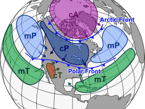
Airmasses
The figure at left shows the main air masses that affect our area. The heat of an airmass is determined by the temperature. The moisture is measured using the dewpoint. Winds associated with high and low pressure systems transport these air masses so that our temperature in the northeast constantly changes. The polar front divides cooler polar air masses from warmer tropical ones and shifts back and forth. The airmass that dominates us usually depends on the prevailing wind.
- Continental polar (cP): cool, dry air brought in by northwest wind
- Continental tropical (cT): warm, dry air brought in from Soutwestern desert
- Maritime tropical (mT): warm, humid air brought in from Gulf of Mexico by southerly winds
- Maritime polar (mP): cool, humid air brought in by eastern or northeasterly winds
posted by ProfWW @ 11:48 PM
0 comments
![]()


0 Comments:
Post a Comment
<< Home