Thursday, September 14

Radar loops

Good radar loops can be found at the National Weather Service. The image at left is from Unisys. Clicking on the image should produce a 6-hour radar loop. Note that the loop shows a blob of precipitation over Eastern Pennsylvania/ Southern New York heading towards Vermont it looks like the next wave of precipitation will hit the Northeast Kingdom sometime this evening. It does look like it will be lighter than predicted.

Locating surface fronts

The image at left shows where front over the northeastern U.S. can be found here. You can download a current maps of fronts and weather systems for all over the U.S. here. In this map, we see the low pressure system responsible for today's cloudy and rainy conditions parked over Lake Erie. A stationary front is analyzed over eastern Pennsylvania. A cold front is analyzed over Northern Ontario and Quebec. Station reports show rain over Southern New England

The fronts shown here are analyzed manually (i.e. by a meteorlogist as opposed to a computer program). They are updated every three hours.

So where's that rain, ProfWW? (Part II)

The data above show precipitation accumalation at New York City's JFK airport. This shows that they had over a quarter inch of rain this morning (before 1751 UTC or 1 PM). This is where the rain can be found.

Precipitation
Amount

0.16 inches In the 3 hours preceding Sep 14, 2006 - 10:51 AM EDT / 2006.09.14 1451 UTC
0.26 inches In the 6 hours preceding Sep 14, 2006 - 01:51 PM EDT / 2006.09.14 1751 UTC
0.19 inches In the 24 hours preceding Sep 14, 2006 - 07:51 AM EDT / 2006.09.14 1151 UTC

So where's that rain, ProfWW?

Unisys 
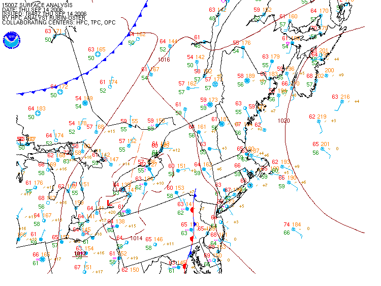
produces a weather summary map of the USA every hour. The map for 16Z (noon EDT) today is shown in the picture at left. An updated version can be found here. this image a good summary map because it plots station data, satellite, imagery, radar imagery, Lows, Highs, and fronts on one information-packed image. One word of warning though. The fronts are not well analyzed.

The current image shows radar imagery in green, yellow, and brown. This is where it is raining; brown is where it is pouring. Vermont is being spared at the moment. Most of the rain associated with the Low centered over Southern Ontario is falling over New York and Southern New England; this is depicted as a green blob centered on NYC. Note also a strong southeasterly wind blowing in from the Atlantic Ocean. This is bringing in lots of moisture from the Atlantic Ocean. Vermont is blocked off from this moist flow by Mount Washington and the White Mountains.

The satellite imagery also shows a line of clearing over western NY and Pensylvania. That is the cold front. Ahead (east) of the cold front is where you find the thickest cloud and heaviest precipitation associated with the weather system. Behind (west of) the front is where you find cooler, drier air that will bring with it clearing. This front is supposed to pass through Vermont sometime this evening.
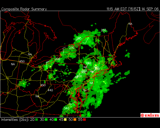
Will we really get over 1/2 " of rain?

Those examining the current conditions on the course weatherpage (or just looked outside) may have noticed that we haven't got anywhere near half an inch of rain out there. Current conditions as of 12:45 (see image) show that only 0.08 inches fell at LSC since midnite last night and that it seems to have stopped raining. Is ProfWW's bold forecast of over 0.5 inches a bust? Stay tuned!

Wednesday, September 13

Over 1/2 inch of rain on Thursday

This chart shows the precipitation that will acumulate between 12Z (7AM) Thursday and Friday. Northeastern Vermont is in the dark blue, meaning that we will receive over .5 inches of rain. That is a good soaking.

For perspective, compare this to the monthly climatology for September. The average rainfall for this month is 3.47 inches per month. Half an inch represents about 1/7 of the rainfall for the whole month.

Fearless prediction: this amount looks about right. There is already a lot of moisture and rain in the Ohio valley. Bring an umbrella on Thursday!

Low pressure to bring rain today

Alas, our run of sunny weather is ending. The 3Z (10 PM EST) satellite and sea-level pressure plot at left show cloud moving in over central Vermont. A warm front extends eastward from a Low pressure system over Lake Michigan. It appears to me that the warm front in fact extends well into New York (not shown on map). Clicking on the NCEP/HPC site shows that this low pressure system is forcast to move eastward and weaken as it approaches us.

Weather on 9/11 5 years ago ...


One thing I found that spooked me last Monday was how similar the weather was over the northeast to that of 9/11 5 years ago. Notice in the figure that a high pressure system was also bringing in northerly winds and pristinely clear skies to New York and all the northeast that morning.

History of high pressure system

Clicking the image at left will animate the image and show that the high pressure system moved into the northeastern U.S. on Sunday. Clockwise flow aroud the high means that northerly winds east of the high pushed in cold air from northern Canada.

High pressure system

Clicking on the image at right will show the weather map for Tuesday morning at 12Z (7 AM EDT) (Image courtesy Unisys) . A high pressure system dominates the northeastern U.S. Note the familiar clockwise flow around the H. Winds to the east of the pressure center blow from the north, while they blow from the south to the west of the sytem. At the center of the high, winds are very weak. Skies are clear around high pressure systems because they are associated with descending air.

Recent weather

Weather Summary for 9/12/2006
Measured in 5 Minute Intervals
High Temperature68.9 F Measured at 17:45
Low Temperature33.1 F Measured at 06:30
Average Temperature49.6 F
Total Precipitation0.00 inches
Highest Wind1.732 mph Measured at 14:10
Average Wind0 mph

The data above for yesterday from the LSC weather station shows that we are under the influence of a cool air mass. Temperatures early Tuesday morning nearly reached freezing (32 F) and temperatures did not make it into the 70's during the day. Winds were very, very light. Comparisons to climatology (the average conditions for this date) at St. Johnnsbury indicate that high temperatures fell below the average of 71 F , whereas low temperatures in the early morning came very close to the record nightime low of 29 F for this date.

Weatherpage


Welcome to Prof W's Weather Blog!

Here we will apply what we learn in the course to current weather. We will begin by describing local weather data resources on the course Weatherpage.

The course weatherpage displays current conditions at LSC's weather station. Current conditions at LSC are shown in the panels at the top. Links to the LSC weather cam and LSC station data can be used to access current and archived data. Click on various links and become familiar with the various data available at LSC's weather server.

The links at the bottom of the page will take you to alternative sources of information on the web. We will begin by examining only the weather maps and data found on this webpage.