Friday, September 29

Quiz preview


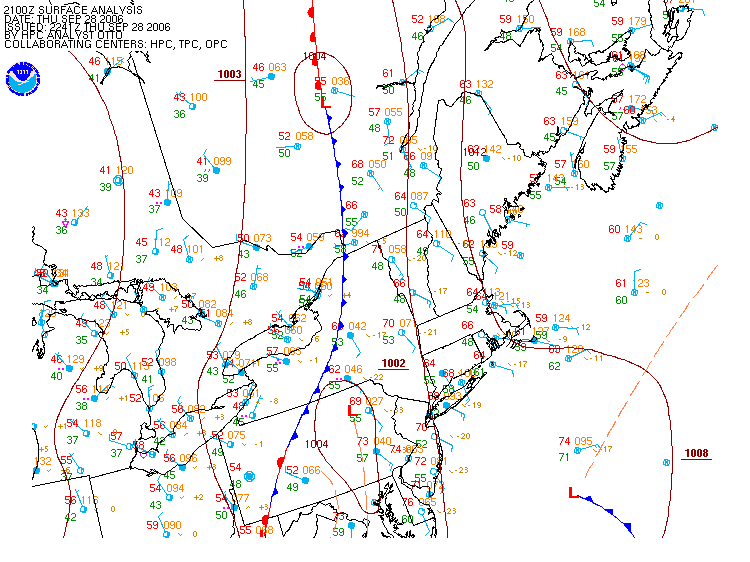
Lucky you! A little preview for the quiz. Clicking on the image at left will give you an idea of the situation last Thursday night as a cold front (blue line) approached Vermont (and all of the Northeast) from the west.

Warm advection is taking place in the southerly winds of the warm sector ahead (east) of the front. A sliver of warm air in excess of 60 degrees F slips into western Vermont. The warm advection is most evident along the coast of New England and New Jersey where south winds cross isotherms at right angles.

Cold advection is most in evidence directly behind the cold front where northwesterly winds cross isotherms from cold to warm portions of the map, slowly pushing that cold air towards Vermont. It's a safe bet that Friday will bring at least a 15 degree F drop in temperatures.

Thursday, September 28

Some thunderstorms


Thursday night. Only one person at the tutorial to witness this cold front arriving. Note the warm advection ahead (east) of the cold front. Strong southerly winds bring in warmer temperatures exceeding 70 degrees F over Vermont. Behind (west of) the front, we see cold advection, with northwesterly winds and temperatures in the the mid 50's. Looks like the rain will start around 9 PM. See animation of this map here.

Tuesday, September 26

Global temperatures reach new records

A study from NASA shows that temperatures are now the highest they've been in 18 000 years.

'The most important result found by these researchers is that the warming in recent decades has brought global temperature to a level within about one degree Celsius (1.8° F) of the maximum temperature of the past million years, which they suggest is a sensible upper limit for additional global warming. “If further global warming reaches 2 or 3 degrees Celsius, we will likely see changes that make Earth a different planet than the one we know. The last time it was that warm was in the middle Pliocene, about three million years ago, when sea level was estimated to have been about 25 meters (80 feet) higher than today.”'

Monday, September 25

ProfWW says:

Most of you have posted your weather blogs already. This is encouraging. If you get nothing else out of this course, you will have learned how to set up a blog!

I think I've managed to leave a comment or two on your blogs just to give you some feedback and nudge you in the right direction in case there is something missing. I've posted links to all blogs I've received on the course web page. Click on "Weatherblogs" in the left hand panel. Links to all student blogs will appear
in the top panel and my own weatherblog will appear below.
You're encouraged to look through the other blogs and read the comments I added to get an idea of what is expected in a weatherblog (I hope I didn't miss anybody). You are also encouraged to leave messages with question, suggestions, additional links, etc. with your classmates. participation counts!

The only rule is to be on topic and civil. Treat the blog like an informal, round-table classroom discussion, except with pictures and links.

Cheers!