Monday, October 2

Today's weather III: Wrap-around cloud and moisture


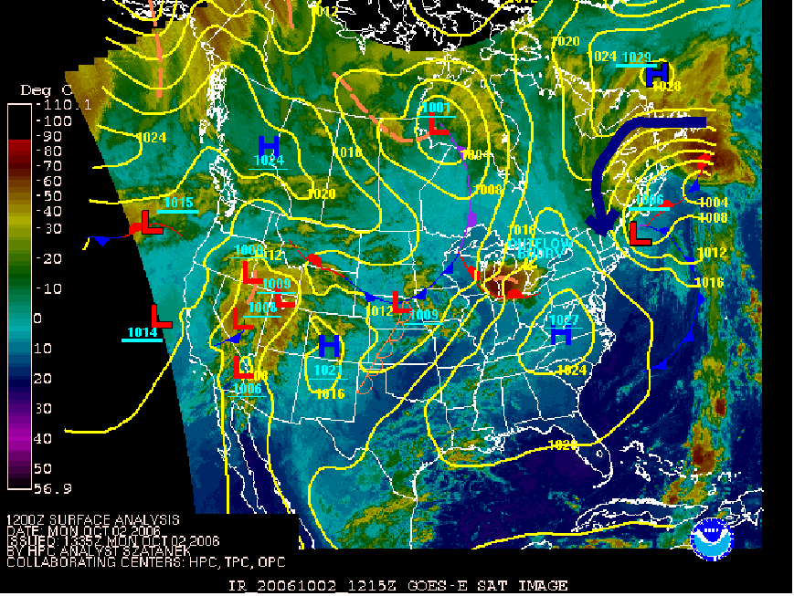
The map at left shows that the mP air that is affecting Vermont today is wrapping around a low pressure system parked off the coast of New England. The circulation around this system is counter-clockwise as indicated by the dark blue arrow (arrow ends over Vermont). This advects in cloud and cool moist air from the North Atlantic (remember, advection refers to wind transporting an air mass). This mass of cloud and moisture is called "wrap around" becasue it appears to curve around the center of the low pressure system.

Note that the blob of cloud off the coast of Newfoundland is the remnants of tropical storm Isaac. The wrap-around today is particularly moist because it taps into the huge amount of cloud and water vapor associated with this storm.

You can view an animation of this system for the past few days by clicking here. Pay attention to the dates at the bottom left of the images.

Today's weather: II Marine polar (mP) air mass


Cool, damp weather almost always means we're under the influence of a marine polar (mP) air mass miving in from the North Atlantic Ocean. Coastal New England sees this type of air far more frequently than Vermont, but Vermont has its fair share of foggy, drizzly days due to mP air masses. The map at left shows that we need easterly or northeasterly winds to bring this air into Vermont.

Today's weather: I Climatology + Current conditions


Here's a few pointers on places to look for temperature data on the web and (more importantly) how to use it.

Climatology for a given day is based on thirty-year averages. It gives you an idea of what the normal temperature is for a given date. The Weather Channel has an easy-to-use website for this (click here). Note that this information is for St. Johnsbury as opposed to Lyndon State college, so that conditions might be slightly different.

For October 2, the average high temperature is 63 F, and the average low temperature is 41 F. Record high and low temperatures are also given.

You may have noticed that it feels cool and damp outside today. You can confirm this by checking the high and low temperature for today at the course weatherpage. Clicking on the "Details" link (shown at left for time of this blog) or going to the "Archive" link under "Current Conditions" indicates a high of 52 F and a low of 46 F.

This illustrates the effect of clouds on temperature. Because clouds block out the sun, the earth does not heat up as much as it might on a sunny day. On the other hand, clouds (especially low-level clouds) also act as a greenhouse agent, absorbing outgoing longwave (IR) radiation and emitting it back towards the Earth's surface. Therefore, the nightime low (46 F) was higher than the normal (41 F) for October 2.

Note that over all, the average temperature for today (48 F) is lower than the climatological mean (52 F) for this date. We appear to be under the influence of a cold air mass.

Why?